Native Peoples of Joshua Tree: Serrano, Chemehuevi, Cahuilla & Mojave History
When most people think of Joshua Tree, they think of the boulders, the twisted trees, the stars. Few think of the people who shaped their relationship with this landscape over thousands of years before any road, parking lot, or visitor center existed here. The Serrano, Chemehuevi, Cahuilla, and Mojave peoples lived here, traveled through here, gathered food here, held ceremonies here, and built communities here across millennia. Their presence is written into the rock — in grinding stones worn smooth by generations of use, in petroglyphs carved near water sources, in sleeping circles stacked against the desert wind. This is an attempt to tell that history fully.
History & Culture
Native Peoples of Joshua Tree
The Serrano, Chemehuevi, Cahuilla, and Mojave peoples have called this desert home for thousands of years. Their history, knowledge, and presence did not end when the park was created.
Joshua Tree National Park occupies the traditional, ancestral, and unceded homelands of the Serrano (Yuhaviatam), Chemehuevi (Nüwüwü), Cahuilla, and Mojave (Pipa Aha Macav) peoples. We acknowledge these nations with respect and gratitude, and we recognize that their connection to this land — its plants, water, rocks, and sky — did not end with the park's creation. It continues today.
A Desert With a Deep Human History
When most people think of Joshua Tree, they think of the boulders, the twisted trees, the stars. Few think of the people who shaped their relationship with this landscape over thousands of years before any road, parking lot, or visitor center existed here.
Archaeological evidence places human presence in the Joshua Tree region at least 5,000 to 8,000 years ago — and possibly much longer. The grinding stones worn smooth by generations of seed-processing, the petroglyphs carved into rock faces near water sources, the sleeping circles of stacked stone arranged as windbreaks in the open desert: these are not ruins. They are the material evidence of peoples who understood this land with a depth that centuries of scientific study have only begun to approach.
Three Native nations held primary presence in the region that is now Joshua Tree National Park: the Serrano, the Chemehuevi, and the Cahuilla. Their territories overlapped, their trade networks intersected, and their cultural relationships were complex and long-standing. Each had their own language, their own governance, their own detailed knowledge of the desert and its resources. And each was subjected to the violence of Spanish colonization, the forced labor of the mission system, the land dispossession of the American period, and ultimately the erasure that comes with having your homeland designated a place for other people to enjoy.
This is an attempt to tell that history fully — not as a footnote to a hiking guide, but as the primary story of this place.
The Four Nations
Who Are the Peoples of Joshua Tree?
Four distinct Native nations held traditional territories within and around the land now called Joshua Tree National Park. Their languages, cultures, and governance systems were distinct — and all four remain living nations today.
The name "Serrano" comes from Spanish missionaries and means "highlander" — a reference to the mountain territory the Serrano occupied. Their own names for themselves — Yuhaviatam and Maarenga'yam — mean "people of the pines" and speak to their deep connection with the pinyon forest zone of the higher Mojave.
The Serrano language belongs to the Uto-Aztecan family, Takic branch — a linguistic family that extends across much of the American West. Active language revitalization efforts are underway today through the San Manuel Band of Mission Indians.
The Serrano occupied the high Mojave Desert above roughly 2,000 feet, including the San Bernardino Mountains and the transitional zone that includes the Oasis of Mara at Twentynine Palms — one of the most significant water sources and habitation sites in the entire region. The higher elevation portions of what is now Joshua Tree National Park fall primarily within traditional Serrano territory.
Descendants of the Serrano include members of the San Manuel Band of Mission Indians, the Morongo Band of Mission Indians, and the 29 Palms Band of Mission Indians, among others.
The Chemehuevi are a Southern Paiute people — a group within the broader Numic branch of the Uto-Aztecan language family. Their name for themselves is Nüwüwü, meaning simply "the people." The name "Chemehuevi" is of uncertain origin, possibly derived from a Mojave-language term. They are known across the region as expert long-distance travelers and traders, with knowledge of desert routes that extended across hundreds of miles.
The Chemehuevi language, a Southern Paiute tongue, is closely related to the languages of other Numic peoples across the Great Basin. Language preservation efforts are ongoing through the Chemehuevi Indian Tribe and the 29 Palms Band.
The Chemehuevi occupied the lower Colorado Desert zone and the Colorado River region, with territory that extended into the eastern portions of what is now Joshua Tree. By the time of sustained European contact, the Chemehuevi were the primary residents of the Oasis of Mara at Twentynine Palms, living alongside Serrano families in this critical water-bearing location.
Living descendants of the Chemehuevi include members of the 29 Palms Band of Mission Indians, the Chemehuevi Indian Tribe on the Colorado River, and Colorado River Indian Tribes.
The Cahuilla are one of the most well-documented Native peoples of Southern California, in part because of the depth and sophistication of their material culture, oral traditions, and ecological knowledge. The meaning of "Cahuilla" in their own language is debated — some scholars suggest it means "masters" or "powerful ones." They are divided into three primary groups based on geography: Desert Cahuilla (Coachella Valley), Mountain Cahuilla (San Jacinto and Santa Rosa ranges), and Pass Cahuilla (San Gorgonio Pass area).
The Cahuilla language is a Takic Uto-Aztecan language, related to Serrano — reflecting the ancient shared linguistic ancestry of peoples across this region. Active documentation and revitalization efforts are ongoing, with the Agua Caliente Band of Cahuilla Indians leading significant language preservation work.
Desert Cahuilla territory extended into the southern portions of what is now Joshua Tree National Park — the Cottonwood Spring area and surrounding low desert. The Cahuilla maintained extensive trail networks connecting the desert floor to mountain food-gathering zones, and their ethnobotanical knowledge — documented by scholars as including over 60 plant species used for food, medicine, fiber, and ceremony — is unmatched in the region.
Descendants of the Cahuilla include members of the Agua Caliente Band of Cahuilla Indians, Cabazon Band of Mission Indians, Torres Martinez Desert Cahuilla Indians, Morongo Band of Mission Indians, Twenty-Nine Palms Band of Mission Indians, and several other federally recognized tribes.
The Mojave (also spelled Mohave) call themselves Pipa Aha Macav — "the people by the river" — a name that speaks directly to their deep identity as a Colorado River people. The Mojave Desert itself takes its name from them. Unlike the Serrano, Chemehuevi, and Cahuilla — who speak Uto-Aztecan languages — the Mojave speak a Yuman language, part of the Hokan language family, reflecting a distinct and ancient linguistic heritage. They are one of the largest Native nations in the Southwest.
Mojave (also called Mohave) is a Yuman language — part of the Hokan language family — making it linguistically distinct from the Uto-Aztecan languages of the Serrano, Chemehuevi, and Cahuilla. This difference reflects separate ancient origins and a long independent cultural development. Language revitalization work is active today through the Fort Mojave Indian Tribe.
The Mojave's primary homeland ran along the Colorado River — centered around the area now called Needles, California, and extending into Arizona and Nevada. Their territory extended into the eastern Mojave Desert, and the NPS has confirmed that the Mojave consider Joshua Tree National Park part of their traditional ancestral homelands. The Oasis of Mara at Twentynine Palms was a significant node on major inter-regional trading routes that the Mojave traveled, and their cultural and trade relationships with the Serrano, Chemehuevi, and Cahuilla were substantial. Unlike the more mobile desert peoples, the Mojave also practiced floodplain agriculture along the Colorado River, growing corn, beans, squash, and melons — making them one of the few desert peoples with a significant agricultural tradition alongside their hunting and gathering.
The Mojave were known across the region as formidable warriors and long-distance travelers, capable of covering remarkable distances on foot. They had an elaborate tradition of tattooing — using tattoos to mark clan identity, spiritual status, and personal history. Their oral literature, including a rich body of dream narratives and song cycles, is among the most complex in the Southwest. Mojave ceramic traditions — producing distinctive pottery — are also well documented in the archaeological and museum record.
Descendants of the Mojave include members of the Fort Mojave Indian Tribe (headquartered in Needles, California), the Colorado River Indian Tribes (which includes Mojave members alongside Chemehuevi, Navajo, and Hopi peoples), and the Fort McDowell Yavapai Nation. The Fort Mojave Indian Tribe actively maintains cultural programs, language revitalization, and tribal sovereignty across their Colorado River homeland.


The Heart of the Region
The Oasis of Mara: Where the Desert Provided
Water is everything in the Mojave Desert. It determines where life concentrates, where trails converge, where peoples meet. For thousands of years, the most significant water source in the Joshua Tree region was the Oasis of Mara — now located within the park near the Oasis Visitor Center in Twentynine Palms.
"Mara" is a Serrano word most commonly translated as "place of little springs and much grass." The oasis produced reliable surface water where springs fed stands of California fan palms (Washingtonia filifera) — the only palm species native to the American Southwest — alongside cottonwood trees, willows, and a richly diverse understory. In a landscape where water sources could be separated by days of travel, Mara was exceptional.
A Gathering Place
Archaeological evidence confirms that the Oasis of Mara has been a site of continuous or near-continuous human habitation for thousands of years. The reliability of water here made it a natural gathering place where Serrano and Chemehuevi families came together — to harvest the resources of the oasis, to trade, to hold ceremonies, and to maintain the social ties that desert survival demanded. The site held cultural and spiritual significance well beyond its material productivity.
Serrano oral tradition holds that a chief with 29 sons planted a palm tree at the oasis for each son — the origin of the name Twentynine Palms. This story, whatever its precise historical relationship to the physical palms at the oasis, encodes the deep connection between Serrano families and this specific place across generations.
What the Oasis Produced
The diversity of life concentrated around the springs made the oasis one of the most resource-rich locations in the region. California fan palm fruits were harvested and eaten fresh or dried for later use. The hearts of young palms were cooked. Cottonwood bark had medicinal applications. The dense shade and stable microclimate supported plant and animal species not found elsewhere in the surrounding desert, creating a zone of exceptional biological productivity that Native peoples understood intimately.
Seasonal Lifeways
How They Lived in the Desert
The picture of desert people "surviving" a harsh landscape misrepresents the reality. The Serrano, Chemehuevi, and Cahuilla did not merely survive the desert — they lived well in it, in part because they understood it with a precision and depth that came from thousands of years of accumulated knowledge, tested and refined across generations. Their movement through the landscape was not aimless wandering; it was a sophisticated seasonal calendar calibrated to when and where specific resources would be available.
Spring: The Low Desert in Bloom
As winter receded and temperatures climbed, the lower desert produced an abundance of tender greens, early seeds, and the first cactus flowers and buds of the year. Cholla cactus buds were harvested in spring using long harvest sticks — wooden tools that allowed pickers to detach the spine-covered buds without injury — then roasted in earth ovens or dried for storage. Prickly pear pads were harvested and eaten as vegetables. The flowers and developing seed pods of the Joshua tree were edible at this stage. Spring was a time of movement through the lower desert zone, gathering and processing the season's first foods.
Summer: Moving to Higher Ground
As the lower desert heated toward summer extremes, families moved to higher elevations in the San Bernardino Mountains and the transitional zone above 4,000 feet. Temperatures there could be 20–30°F cooler than the desert floor. This seasonal movement was not flight from heat — it was a deliberate strategy that maximized access to a wider range of environments and their resources across the year.
Fall: The Pinyon Harvest
The fall pinyon pine nut harvest was arguably the most important food-gathering event of the year. Pinyon pines grow in the higher elevation zones of the Mojave, producing small, protein- and fat-rich nuts that could be stored for months and provided critical nutrition through the winter. Entire extended family groups traveled to known pinyon groves, harvested cooperatively, and processed large quantities of nuts for storage. The harvest was also a social occasion — a time when families who had traveled through separate territories over the spring and summer came together. Trade goods exchanged hands at these gatherings: shell beads from the coast, obsidian from the eastern Sierras, pottery, dried foods.
Winter: Conservation and Community
Winter months in the lower desert were mild enough to sustain habitation, and stored foods — dried seeds, pinyon nuts, dried cactus fruit, mesquite flour — sustained communities through the cooler months. Winter was a time for ceremony, craft production, story, and social maintenance: the work that binds communities together across generations.
Shelter and Settlement
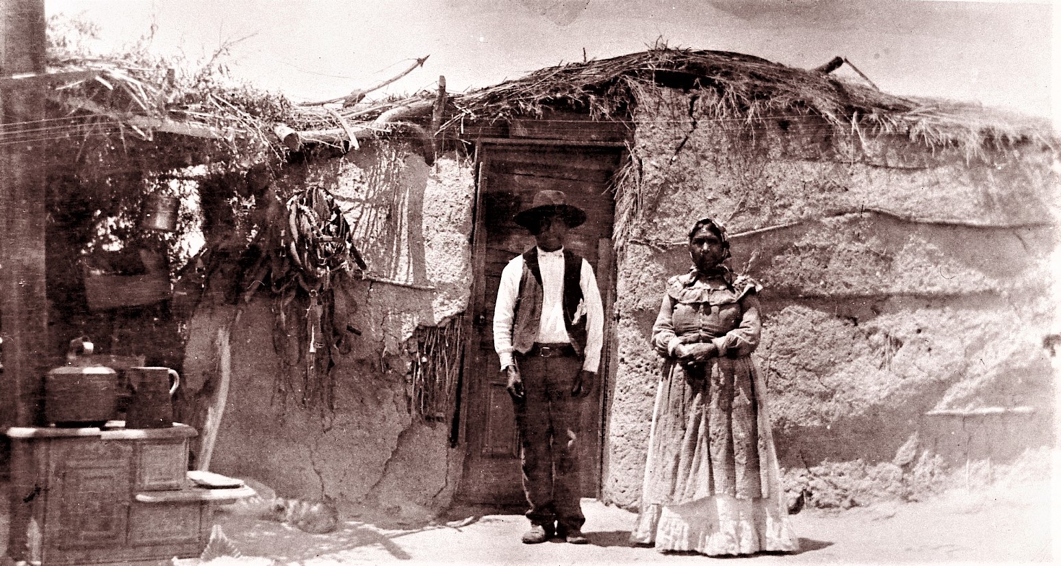
Structures varied by season and location. At longer-term habitation sites near water sources, more substantial homes were built — dome-shaped structures framed with willow or cottonwood poles and covered with brush, grass, or palm leaves. At temporary camps in the open desert, simpler brush windbreaks and sleeping circles — rings of stacked stones that cut the wind and retain heat — sufficed. Hundreds of sleeping circles survive in the backcountry of Joshua Tree today, quiet evidence of every generation that camped across these rocky flats.
Ethnobotany
Plants as Knowledge, Food, Medicine & Material
The Cahuilla alone have been documented using over 60 desert plant species for food, medicine, fiber, dye, and construction — a body of ecological knowledge built over millennia of close observation and experimentation. The Serrano and Chemehuevi maintained their own equally sophisticated plant knowledge systems. Below are some of the most significant species in the Joshua Tree landscape and how they were used.
Flower buds harvested in early spring and eaten raw or roasted; seed pods consumed. Leaves provided tough fibers for weaving baskets, sandals, and cordage. Roots yielded a reddish-brown dye. Trunk sections were sometimes used as roofing material. The Chemehuevi referred to the Joshua tree as humwichawa.
One of the single most important food plants in the low desert. Seed pods ground into flour (pinole) and processed into atole (porridge), cakes, and beverages. The flour was also fermented into a mildly alcoholic beverage for ceremonial use. Mesquite pods could be stored for months — a critical winter food reserve. Wood used for tools and fuel; bark for clothing and shelter.
The heart of the agave was roasted in large earth pits lined with hot stones for one to three days, producing a sweet, nutritious food. The leaves provided one of the most versatile fibers in the desert — used for cordage, nets, clothing, and baskets. The flower stalk was eaten when young and roasted. Spines served as needles and awls.
The annual pinyon pine nut harvest was the most important food-gathering event of the year for high-desert peoples. Nuts are exceptionally nutritious — high in protein, fat, and calories — and store well for months when dried. They were eaten raw, roasted, ground into flour, and processed into a rich nut butter. Entire family groups traveled to known groves each fall for cooperative harvest.
Spring buds harvested using long wooden sticks (harvest sticks) that allowed pickers to detach spine-covered buds without contact. Buds were roasted in earth pits or on hot coals, then eaten fresh or dried for storage. Dried buds were an important trade good. The ribs of dead cholla provided lightweight construction material for small structures.
Found only at reliable water sources, the fan palm was a marker of precious oases. Its small fruits were eaten fresh or dried and ground into flour. Young palm hearts were roasted and eaten. The large dried leaves provided thatch for shelter roofing. The fibrous leaf skirt that builds up on mature palms was used for kindling and insulation material.
One of the most medicinally significant plants in the desert pharmacopeia. Leaves and stems were brewed into a tea used to treat colds, respiratory infections, and pain. A resin produced by the plant was applied topically to wounds, skin irritations, and as a waterproofing agent for baskets and pottery. The plant's distinctive rain smell (from the compound NDGA) was recognized as a sign of incoming moisture.
The flexible young branches of the desert willow provided ideal material for basket frames and woven structures. The seeds were consumed, and the flowers were eaten as a food source. The bark had medicinal applications as an antifungal treatment. Desert willow grew along washes and arroyos — linear zones of deeper soil and occasional water that were important movement corridors through the landscape.
Archaeological Evidence
Rock Art, Grinding Stones & the Written Desert
The rocks of Joshua Tree are not empty. They carry two categories of marks made by human hands across thousands of years: petroglyphs (images carved or pecked into rock surfaces) and pictographs (images painted onto rock faces). Together with the grinding stones, pottery shards, and sleeping circles scattered across the backcountry, they constitute a material record of sustained human presence that predates the park by millennia.
Petroglyphs at Barker Dam
The most accessible rock art in Joshua Tree is the petroglyph panel at Barker Dam, reachable via the Barker Dam Loop Trail (1.3 miles). The carvings include geometric designs — spirals, grids, concentric circles — as well as animal and anthropomorphic figures. The precise meanings of these images remain a matter of scholarly debate and, more importantly, tribal knowledge. Archaeological interpretation has proposed multiple functions: territorial markers, ceremonial or cosmological records, astronomical observations, and map-like notations of water sources. Tribal oral traditions hold additional layers of meaning that external researchers may never fully access.
One important note for visitors: some of the Barker Dam petroglyphs were over-painted with paint in the 1950s during the filming of a Western movie. The original carvings survive beneath the paint, but this episode of careless destruction is a reminder that rock art requires active protection.
Grinding Stones
Among the most common and widespread archaeological features in Joshua Tree are grinding stones — bedrock morteros and portable metates — used for processing seeds, nuts, and other plant materials. Morteros are circular depressions ground into large granite boulders; the deepest examples show the cumulative work of generations of grinding, their basins worn inches into the rock. They are found near water sources, at habitation sites, and along travel routes across the park. When you see a granite boulder with smooth, rounded depressions — often in clusters — you are looking at a kitchen that fed families for centuries.
Sleeping Circles
Hundreds of sleeping circles — simple rings of stones arranged as windbreaks, typically 6 to 8 feet in diameter — survive in the backcountry. They were used as temporary shelter during travel, their low walls deflecting the night wind while a person slept inside. Their distribution across the park maps the travel routes of generations of people moving between water sources, food-gathering zones, and neighboring communities.
Regional Networks
Trade, Connection & the Desert as Crossroads
The peoples of the Joshua Tree region were not isolated desert communities. They were active participants in trade networks that extended hundreds of miles in every direction — connecting the Pacific coast to the Colorado River, the Sierra Nevada to the Sonoran Desert. The desert was not a barrier to movement. For peoples with deep knowledge of its water sources, seasonal resources, and trail systems, it was a highway.
Shell beads — made from the shells of olivella and abalone — moved inland from coastal Tongva (Gabrielino) and Chumash peoples, traveling through a series of exchange relationships until they reached the Colorado Desert and beyond. Turquoise moved west from mining areas in what is now Arizona and New Mexico. Obsidian — a volcanic glass prized for its edge — moved south from quarries in the eastern Sierra Nevada. Steatite (soapstone) from Catalina Island moved into the interior as bowl-making material. Pinyon pine nuts moved in the opposite direction — from the higher desert to the coast — as a dense, storable trade good.
The Chemehuevi were particularly known for their travel and trading expertise. Their routes connected the Colorado River to the Pacific Coast and north into the Great Basin, making them important middlemen in regional exchange. The Cahuilla, positioned at the geographic center of Southern California's trading networks, were equally significant nodes in this web of exchange. And the Serrano, occupying the mountain and high-desert transitional zone, controlled access to some of the most resource-rich pinyon-juniper habitat in the region.
These relationships were not purely economic — they were diplomatic and social. Trade maintained alliances between groups, created obligations of hospitality and reciprocity, and enabled the movement of cultural practices, ceremonies, songs, and technologies across vast distances. The desert was not empty space between communities. It was the medium through which they remained connected.

Contact, Colonization & Dispossession
What Colonization Did to the Peoples of This Desert
The first sustained contact between the peoples of the Joshua Tree region and European colonizers came through the Spanish mission system, which extended its reach into Southern California beginning with the founding of Mission San Diego in 1769 and Mission San Gabriel in 1771. Within a few decades, the mission system's reach extended to Serrano and Cahuilla communities.
The Mission System
The Spanish missions operated on a model of forced settlement, forced labor, and forced religious conversion. Native peoples were compelled to leave their villages and seasonal movement patterns and relocate to mission grounds, where they were made to work in fields and workshops under conditions that historian Sherburne Cook described as producing catastrophic demographic collapse. European diseases — measles, smallpox, influenza — swept through populations with no prior exposure and no immunity. Some estimates place the population decline among Southern California Native peoples at 90 percent or more within a century of sustained contact. Communities that had numbered in the thousands were reduced to dozens.
The Serrano word for the mission period records something of what it meant: the missions are associated in oral tradition with death, captivity, and the violent suppression of traditional practice. Ceremonies were prohibited. Languages were punished. The movement between seasonal territories that sustained life and culture was made impossible.
Mexican Period (1821–1848)
Mexican independence from Spain in 1821 changed governance but not the fundamental condition of Native peoples in Southern California. The secularization of the missions in 1833 theoretically freed Native people from mission labor — but in practice, mission lands were distributed to elite Mexican families, and many former mission workers became landless laborers on ranches, subject to debt peonage and continued displacement. Those who returned to their traditional territories found them increasingly occupied by ranchers and settlers.
American Period and the California Genocide
The United States acquired California from Mexico in 1848 under the Treaty of Guadalupe Hidalgo. The California Gold Rush of 1849 unleashed a flood of settlers into the state, and the state and federal governments developed policies toward Native peoples that combined forced removal, destruction of food sources, and sanctioned violence. The California state government paid bounties for Native scalps and ears during the 1850s and 1860s — a period California Governor Gavin Newsom formally acknowledged in 2019 as genocide. The Native population of California fell from an estimated 150,000 at the time of American acquisition to roughly 16,000 by 1900.
In this context, the peoples of the Joshua Tree region — Serrano, Chemehuevi, Cahuilla, and Mojave — were pushed onto reservations that were fractions of their traditional territories, cut off from seasonal food-gathering routes, and subjected to federal policies designed to erase their cultures, languages, and governance systems.
The Reservation System
Executive Order reservations for Southern California tribes were established in waves beginning in the 1860s. The lands set aside were typically the least productive portions of traditional territories — rocky hillsides, alkaline flats, locations without reliable water. The rich oases, the pinyon groves, the valley floors with deep soil — these remained outside reservation boundaries. Federal Indian boarding schools removed children from their families and communities, forbidding Native languages and cultural practices in an explicit policy of cultural destruction.
1936 & After
The Park's Creation and Its Cost to Native Communities
Joshua Tree National Monument was established by President Franklin D. Roosevelt on August 10, 1936, largely through the advocacy of Minerva Hoyt, a wealthy Pasadena socialite and conservationist who campaigned for years to protect the desert landscape from commercial collecting of cacti and Joshua trees. Hoyt's advocacy was genuine and consequential. But the monument she helped create was superimposed on a landscape that was already someone's home.
The designation of the monument incorporated lands within the traditional territories of the Serrano, Chemehuevi, and Cahuilla peoples — lands where Native families had continued to live, gather food, and maintain cultural connections through the reservation era. With federal monument status came federal control and, over time, the removal of the remaining Native presence. Families who had survived colonization, disease, the mission system, and the reservation era now found themselves displaced from the last portions of their homeland that they had continued to use.
The 29 Palms Band of Mission Indians
The most direct impact fell on the 29 Palms Band of Mission Indians — descendants of the Chemehuevi and Serrano peoples who had long occupied the Oasis of Mara and surrounding lands. Their tribal reservation in Twentynine Palms, established in 1974, covers approximately 40 acres — one of the smallest Indian reservations in the United States. The traditional territory it represents: tens of thousands of acres, now administered as a national park.
The 29 Palms Band has continued to assert its cultural and political relationship to its ancestral lands, including through formal consultation with the National Park Service. The tribe's leadership has worked to ensure that the NPS acknowledges and presents Native history at the Oasis of Mara and throughout the park's interpretive programming. This advocacy has produced some meaningful results — the NPS now maintains cultural interpretation at the Oasis Visitor Center and has formal tribal consultation protocols — but the fundamental asymmetry remains: a tribe of a few dozen members holds a 40-acre reservation while the park they consider their homeland receives over 3 million visitors per year.
The Monument Becomes a National Park
The California Desert Protection Act of 1994 elevated Joshua Tree from National Monument to National Park status and expanded its boundaries. For the surrounding Native communities, this expansion represented another extension of federal control over ancestral territory — with no meaningful change in the conditions of Native access to sacred sites, traditional food-gathering areas, or the water sources their ancestors depended on.
Living Nations
Tribal Nations Connected to Joshua Tree Today
The peoples of Joshua Tree are not historical figures. They are living nations — with tribal governments, language programs, cultural preservation efforts, and members who maintain active relationships to their ancestral landscape. Several federally recognized tribes are formally connected to the Joshua Tree region through ancestry, territory, and ongoing NPS tribal consultation.
The tribe most directly connected to the Oasis of Mara and the Joshua Tree park area. Their Twentynine Palms reservation is approximately 40 acres. They maintain active consultation with the NPS and advocate for recognition of Native history throughout the park. Tribal website: 29palmstribe.com
One of the largest and most active Serrano tribal governments in California. The San Manuel Band operates extensive cultural and language preservation programs and maintains its connection to the broader Serrano homeland, which includes the high Mojave zone of Joshua Tree. Tribal website: sanmanuel.com
Based in Palm Springs, the Agua Caliente Band maintains active cultural programs including the Agua Caliente Cultural Museum — the most significant institutional resource for Cahuilla history and culture in the region. Their traditional territory extended into the southern Joshua Tree area. Tribal website: aguacaliente.org
Located near Cabazon at the juncture of Serrano and Cahuilla traditional territories, the Morongo Band maintains cultural connections to both nations. Their reservation sits at the entrance to the San Gorgonio Pass — a significant travel corridor between the coastal and desert zones that their ancestors used for millennia.
Based on the Colorado River, the Chemehuevi Indian Tribe maintains its connection to the broader Chemehuevi homeland, which extended into the Joshua Tree region. The tribe operates cultural preservation programs and maintains its language revitalization work. Tribal website: chemehuevi.net
Located in the Coachella Valley, the Cabazon Band are Desert Cahuilla — the group whose traditional territory included the lower Colorado Desert portions of Joshua Tree. Their reservation is near Indio, in the heart of their ancestral desert homeland.
Visiting as a Guest
How to Visit Joshua Tree Respectfully
Visiting a national park as a guest on Native land comes with responsibilities. Some of these are legal — violations of the Archaeological Resources Protection Act carry serious federal penalties. Others are ethical: the difference between tourism that extracts and tourism that honors. These guidelines are a starting point.
Oils from clean hands cause chemical damage to petroglyphs and pictographs over time. Do not touch, trace, chalk, or apply anything to rock art surfaces. Photograph only — and from a respectful distance.
Removing any object — pottery shard, stone flake, shell bead, grinding stone — from the park is a federal felony under ARPA. But beyond the legal issue: these objects belong to the people whose ancestors made them, and they belong in the landscape where they were left.
Take time before your visit to read about the Serrano, Chemehuevi, Cahuilla, and Mojave peoples — not just their past, but their present. Knowing whose land you're on changes how you experience it.
The NPS maintains interpretive exhibits on Native history at the Oasis Visitor Center. The Oasis of Mara trail itself (0.5 miles) passes through one of the most culturally significant sites in the park.
If you encounter stone rings, grinding stones, or other archaeological features in the backcountry, do not enter, sit in, or disturb them. Note the GPS location and report it to the NPS if you believe it is undocumented.
The Agua Caliente Cultural Museum in Palm Springs, the cultural programs of the San Manuel Band and 29 Palms Band, and the language revitalization efforts of multiple tribes all welcome public support and engagement.
Continue Learning
More History & Background
Minerva Hoyt, the CCC, mining history, Bill Keys, and how this desert became one of America's most visited parks.
Why the boulders are round, how two deserts meet here, and what the rocks reveal about deep time.
with guides who know it deeply.
Common Questions
Native Peoples of Joshua Tree — FAQ
The land that is now Joshua Tree National Park was home to the Serrano (Yuhaviatam), Chemehuevi (Nüwüwü), and Cahuilla peoples for thousands of years, with archaeological evidence of human habitation dating back at least 5,000 to 8,000 years. These peoples lived here seasonally, following food resources through the high Mojave and low Colorado Desert zones, and maintained complex social, spiritual, and material cultures deeply tied to this landscape.
Mara is a Serrano word most commonly translated as "place of little springs and much grass." The Oasis of Mara — now within Joshua Tree National Park near the Oasis Visitor Center — was one of the only reliable water sources in the region and a significant gathering and habitation site for Serrano and Chemehuevi peoples. Serrano oral tradition holds that a chief had 29 sons who each planted a palm tree at the oasis — the origin of the name Twentynine Palms.
The most accessible site is the petroglyph panel at Barker Dam, on the Barker Dam Loop Trail (1.3 miles). The Oasis of Mara near the Oasis Visitor Center is itself a significant cultural site with NPS interpretive exhibits. Grinding stones (morteros) are visible at several locations. Many additional sites — rock art, sleeping circles, pottery scatters — exist throughout the backcountry and are protected under federal law. Do not touch, disturb, or remove anything from archaeological sites.
Joshua trees were a significant multi-use resource. The flower buds were harvested in early spring and eaten raw or roasted; seed pods were also consumed. The tough leaf fibers were used to make baskets, sandals, and cordage. The roots yielded a reddish-brown dye. Trunk sections were sometimes used as roofing material. The Chemehuevi referred to the Joshua tree as humwichawa. Far from being incidental to desert life, the Joshua tree was woven through the material and food culture of these peoples.
Yes. Several federally recognized tribal nations maintain active cultural and political connections to the Joshua Tree area. The 29 Palms Band of Mission Indians — descendants of Chemehuevi and Serrano peoples — holds a small reservation in Twentynine Palms and participates in ongoing NPS tribal consultation. The San Manuel Band of Mission Indians (Serrano), Morongo Band, Agua Caliente Band of Cahuilla Indians, Chemehuevi Indian Tribe, and others are also connected to this landscape through ancestry, cultural practice, and formal consultation relationships.
When Joshua Tree was designated a National Monument in 1936, it incorporated lands where Native peoples had lived, traveled, and maintained cultural connections for millennia. Families who had continued to use the land were removed or had their access severely restricted. The 29 Palms Band of Mission Indians — whose traditional territory included the Oasis of Mara and surrounding lands — was left with one of the smallest reservations in California: approximately 40 acres. Their loss of access to traditional food-gathering areas, water sources, and sacred sites was profound and is an ongoing legacy.
Never touch, trace, or alter rock art — skin oils cause irreversible chemical damage. Do not remove any objects from the park (federal law under ARPA). Stay on designated trails near known archaeological sites. Visit the Oasis Visitor Center and engage with the NPS interpretive exhibits on Native history. Take time before your trip to learn about the Serrano, Chemehuevi, and Cahuilla peoples — their histories, their current communities, and their ongoing cultural work. The Agua Caliente Cultural Museum in Palm Springs is an excellent resource to visit alongside a trip to Joshua Tree.
The NPS Oasis Visitor Center has exhibits on Native peoples of the region. The 29 Palms Band of Mission Indians (29palmstribe.com) documents their history and sovereignty. The Agua Caliente Cultural Museum in Palm Springs offers deep resources on Cahuilla history and culture. The San Manuel Band of Mission Indians (sanmanuel.com) documents Serrano history and language revitalization. For reading: Lowell John Bean's ethnobotanical scholarship on the Cahuilla, and Clifford Trafzer's work on Southern California Native history, are valuable starting points.
Summit Climbing Guides
Go Deeper Into Joshua Tree
Our guided adventures take you into the backcountry — into the landscape that has sustained human life for thousands of years. Rock climbing, caves, off-trail routes, and more.
Book a Guided Adventure