History of Joshua Tree National Park: Mining, Minerva Hoyt & How the Desert Was Saved
Most visitors to Joshua Tree National Park come for the boulders, the sunsets, the otherworldly silence. They may not think much about how 792,000 acres of desert came to be protected federal land — but that story, stretching from the arrival of Spanish missionaries to a Mississippi-born conservationist lobbying FDR in the depths of the Great Depression, is as strange and compelling as the landscape itself.
Joshua Tree's history is a story told in layers. Beneath the surface of every trail and campground are the traces of the Native peoples who lived here for millennia, the prospectors who came for gold in the 1890s, the ranchers and homesteaders who built lives in the desert heat, the cactus poachers who nearly stripped the landscape bare, and finally the unlikely coalition of conservationists, New Deal bureaucrats, and presidential proclamation that drew a boundary around the desert and said: this stays.
This is that story.
History of Joshua Tree National Park
From gold miners and cattle ranchers to a conservation crusader and a president's proclamation — how 792,000 acres of desert became one of America's most beloved national parks.
The land that became Joshua Tree National Park has been home to the Serrano (Yuhaviatam), Chemehuevi (Nüwüwü), Cahuilla, and Mojave (Pipa Aha Macav) peoples for thousands of years. The park's "founding" in 1936 was not a beginning — it was a chapter in a much longer story. Read the full history of the Native peoples of Joshua Tree →
Long Before the Park Had a Name
Most visitors to Joshua Tree National Park come for the boulders, the sunsets, the otherworldly silence. They may not think much about how 792,000 acres of desert came to be protected federal land — but that story, stretching from the arrival of Spanish missionaries to a Mississippi-born conservationist lobbying FDR in the depths of the Great Depression, is as strange and compelling as the landscape itself.
Joshua Tree's history is a story told in layers. Beneath the surface of every trail and campground are the traces of the Native peoples who lived here for millennia, the prospectors who came for gold in the 1890s, the ranchers and homesteaders who built lives in the desert heat, the cactus poachers who nearly stripped the landscape bare, and finally the unlikely coalition of conservationists, New Deal bureaucrats, and presidential proclamation that drew a boundary around the desert and said: this stays.
This is that story.
The First 10,000+ Years
Ancient Peoples of the Desert
Archaeological evidence places human habitation in the Joshua Tree region as far back as 10,000 years — and possibly longer. Long before the park had a boundary, before it had a name, the Serrano, Chemehuevi, Cahuilla, and Mojave peoples knew this desert in extraordinary detail. They had names for its plants, its water sources, its seasonal rhythms. They left grinding stones worn deep into boulders, sleeping circles built from stacked stones, and petroglyphs carved into rock faces.
This history deserves its own telling — and it has one. The first sustained European contact came through the Spanish mission system in the late 1700s. The 19th century brought dispossession, disease, and the violent policies of the American period. What is now a national park was once a homeland — a fact that does not disappear when a boundary is drawn.
1880s – 1910s
The Gold Rush Comes to the Desert
California's great Gold Rush of 1849 had come and largely gone by the time prospectors turned serious attention to the Mojave Desert — but gold doesn't respect timelines, and the desert did have gold. By the 1880s and 1890s, prospectors were working their way into the high desert north of Palm Springs, staking claims in remote canyons, camping beside Joshua tree groves, and building the rough infrastructure of hard-rock mining in one of the most inhospitable environments on earth.
The desert posed brutal challenges. Water was scarce and had to be hauled or found. The heat was extreme. Everything — ore carts, stamp mill machinery, fuel, food — had to be brought in over rough desert tracks. But where gold is concerned, logistical hardship rarely stops determined men, and the Little San Bernardino Mountains had enough of it to draw real investment.
Lost Horse Mine
The most significant gold mining operation in what is now Joshua Tree National Park began in the early 1890s in the mountains west of the Pinto Basin. The Lost Horse Mine — so named for a horse that wandered into the canyon and led its searcher to the gold-bearing quartz deposits — was developed by prospector Johnny Lang into one of the most productive mines in the region.
Lang built a ten-stamp mill at the site, powered by steam, to crush the ore-bearing rock and extract its gold through an amalgamation process using mercury. The stamps — each weighing several hundred pounds — dropped rhythmically onto the ore, their thunder carrying across the desert. At its peak production, the Lost Horse Mine yielded an estimated five million dollars in gold at 1890s prices — a staggering sum for a remote desert operation. Cyanide vats were later added to recover gold from the waste tailings, a technology introduced in the 1890s that dramatically improved extraction rates.
Operations at Lost Horse continued into the early 1900s. Today the ruins of the original stamp mill — its massive timber frame, the ore chutes, the concrete cyanide tanks, the foundations of the engine house — remain exactly where they were left, preserved in the dry desert air. The Lost Horse Mine Loop Trail (4.2 miles round trip) leads hikers to a fenced viewing area above the mill site.
Desert Queen Mine
Located in Queen Valley in the northern section of the park, the Desert Queen Mine was another significant gold producer discovered in 1894. The mine passed through multiple owners over the decades, including colorful figures like Bill McHaney — a suspected cattle rustler who claimed the location — and later the aggressive mining promoter James Swinnerton. The Desert Queen ran through multiple boom-and-bust cycles, with periods of intensive mining followed by abandonment as gold prices fluctuated and ore grades declined. Its ruins remain accessible within the park.
Wall Street Mill
Not all ore in the Joshua Tree region could be processed on-site. Some mines needed an external mill to crush their rock. The Wall Street Mill — located near Barker Dam in the Wonderland of Rocks area — was built in the 1920s as a custom stamp mill that could process ore from multiple operations in the region. The mill eventually came under the control of Bill Keys, who operated it for years and left the machinery largely intact when operations ceased. It is one of the best-preserved historic stamp mills accessible in the park today, reachable via a 1.5-mile round-trip trail.


.jpg)
1910 – 1969
Bill Keys and the Desert Queen Ranch
No single figure looms larger over the human history of the Joshua Tree region than William Francis Keys — prospector, rancher, blacksmith, builder, convicted killer, and desert patriarch. Keys arrived in the high Mojave around 1910 and spent nearly six decades there, outlasting most of the miners, ranchers, and drifters who passed through before and after him. His story is one of the most compelling in the history of the American West.
Building a Life in the Desert
Keys homesteaded at what became the Desert Queen Ranch, in a valley near Queen Mountain in the northern portion of the park. He didn't just survive the desert — he conquered it on its own terms. He built a house, a workshop, a schoolhouse for his children, an orchard, and an assortment of outbuildings using whatever materials the desert provided or he could haul in. He welded, repaired, and fabricated machinery for his own mines and for others throughout the region. He ran cattle. He operated the Wall Street Mill, processing ore for neighboring miners. He dug his own dams.
Keys married Frances May in 1918 and raised five children at the ranch. In an era before paved roads, power lines, or reliable water delivery, the Keys family created a functioning homestead that lasted decades — a feat of practical engineering and raw determination that is genuinely difficult to appreciate from the comfort of a paved trail.
The Bagley Shooting
On May 11, 1943, Bill Keys shot and killed his neighbor Worth Bagley at the edge of a road on the desert floor. The precise sequence of events was disputed at trial — Keys claimed Bagley drew a weapon first, Bagley's widow disputed this — but the jury believed the prosecution's account, and Keys was convicted of manslaughter and sentenced to prison. He was 64 years old.
Keys served five years at San Quentin State Prison before being pardoned by Governor Earl Warren in 1956. His release was secured largely through the advocacy of Erle Stanley Gardner — the mystery writer famous for creating Perry Mason — who became convinced of Keys's version of events and mounted a dogged public campaign on his behalf. Keys returned to his desert ranch, where he lived until his death in 1969 at the age of 89.
Keys Ranch Today
The Desert Queen Ranch — now known as Keys Ranch — is a National Historic Landmark within Joshua Tree National Park. The NPS offers ranger-led tours of the property, walking visitors through the house, workshop, orchard, and grounds where Bill Keys spent most of his long life. The ruins of vehicles, machinery, and outbuildings are preserved largely as Keys left them. It is one of the most evocative historical sites in any national park in California.
1920s – 1936
The Cactus Poachers and the Woman Who Said No
By the late 1920s, Joshua Tree faced a new and less glamorous threat than gold mining. The expansion of automobile roads into the Mojave opened the desert to a wave of Southern California day-trippers, real estate speculators, and — most destructively — commercial plant collectors who were systematically stripping the desert of its most spectacular flora. Joshua trees were being uprooted and transplanted to suburban gardens. Cholla, yucca, and rare cacti were being sold in nurseries and at roadside stands. Entire hillsides were being cleared for development schemes that rarely materialized.
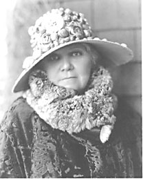
It was this destruction that mobilized Minerva Hamilton Hoyt.
Minerva Hamilton Hoyt
Hoyt was born in 1866 on a Mississippi plantation, educated at finishing schools, trained in music conservatories. Her marriage to Dr. Sherman Hoyt eventually brought her to South Pasadena, where she threw herself into the civic life of Southern California's upper class — charity events, garden clubs, the organizational machinery of women's civic culture in the early 20th century.
Her passion for plants, particularly the strange and austere beauty of desert species, grew out of her gardening work and the day trips she began making into the Mojave. Hoyt saw beauty in the landscape that most of her contemporaries dismissed as worthless wasteland. She also saw what was being destroyed. The poaching and careless vandalism of desert plants struck her as intolerable, and in the wake of personal tragedy — the deaths of her son and her husband — she redirected her formidable organizational energy toward the desert's protection.
Taking the Desert to the World
Hoyt's strategy was bold. To save an American desert landscape that most Americans had never seen and did not care about, she decided to make them care — by bringing the desert to them. She organized enormous exhibitions of living desert plants and carried them to Boston, New York, and London, where they drew substantial crowds and press coverage. She was not operating from the field or laboratory; she was operating from ballrooms and reception halls, making the case for desert conservation to people who controlled money and political access.
She founded the International Deserts Conservation League with the explicit goal of establishing protected parks for desert landscapes. She was appointed by noted landscape architect Frederick Law Olmsted Jr. to serve on a California state commission recommending new state park sites. Her commission report recommended large parks at Death Valley, the Anza-Borrego Desert, and in the Joshua tree forests of the Little San Bernardino Mountains — an early and explicit articulation of the park that would eventually exist.
Reaching the President
Hoyt understood that a state park would not be enough — only federal designation would provide the scale of protection the Joshua Tree desert needed. She hired biologists and desert ecologists to prepare scientific reports on the region's ecological value. She cultivated an ally in Secretary of the Interior Harold Ickes, who was sympathetic to ambitious public land designations. She eventually secured access to President Roosevelt himself — who was already using the National Park and Monument system as a mechanism for his New Deal jobs program. The establishment of new protected areas created work for the Civilian Conservation Corps and the broader federal labor programs of the Depression era.
Problems with railroad land grants in the proposed area forced a reduction from Hoyt's original proposal of over one million acres to a more modest 825,000 — but the essential designation moved forward. On August 10, 1936, President Roosevelt signed the presidential proclamation establishing Joshua Tree National Monument. Minerva Hoyt, then 70 years old, had her park.
August 10, 1936
National Monument: 825,000 Acres Protected
The establishment of Joshua Tree National Monument in 1936 was one of the largest desert land designations in American history up to that point. The 825,000-acre monument encompassed the high Mojave Desert zone north of Palm Springs — the Joshua tree forests of the Little San Bernardino Mountains — along with the lower Colorado Desert ecosystems that abutted it from the south.
Administration of the new monument was initially delegated to the superintendent of Yosemite National Park — a sign of both the federal government's genuine commitment to the new designation and its limited administrative capacity to stand up a new operation in a remote California desert. The first dedicated superintendent, James Cole, was not appointed until 1940, four years after the proclamation. Cole arrived to an essentially unsupervised monument: no visitor infrastructure, no real enforcement presence, and mining and ranching operations that continued within the monument's boundaries under grandfathered rights.
The Civilian Conservation Corps
The CCC's presence in Joshua Tree transformed the monument from a protected designation on paper to an accessible landscape with real visitor infrastructure. CCC crews — young men employed through Roosevelt's New Deal in Depression-era work programs — built the campgrounds, roads, trails, and water systems that became the foundation of Joshua Tree's visitor experience. The men worked in brutal desert conditions, living in camps within the monument and constructing infrastructure that still underlies much of what visitors use today. Their work was extraordinary in its scope and quality, carried out with hand tools and mule teams in a landscape that remained genuinely remote.
1950: Boundary Adjustments
The monument's first major boundary change came in 1950, when the Oasis of Mara — long a sacred and cultural site for the Chemehuevi and Serrano peoples — was formally deeded to the National Park Service by the Twentynine Palms Corporation. That same year, 265,000 acres were removed from the monument's boundaries to exclude certain active mining properties, reducing it from the original 825,000 acres. The removal of mining lands reflected the political reality of the postwar era, in which resource extraction interests maintained significant leverage over public land policy.

1940s – 1970s
War, Wilderness, and a Monument Under Pressure
The years following the monument's establishment were not quiet. During World War II, the adjacent desert was used extensively for military training — General George Patton based his Desert Training Center at camps throughout the Mojave, preparing armored divisions for the North African campaign. The monument itself was largely spared, though the proximity of military operations shaped the postwar landscape of the region.
The postwar economic boom brought new pressures on the monument in the form of mining claims, grazing interests, and real estate development on its edges. The 1950 boundary reduction that removed 265,000 acres of mining land was partly a product of this postwar political climate, which favored resource extraction over conservation. Throughout the 1950s and 1960s, the monument remained relatively obscure — a place that rock climbers discovered in the 1950s, that beatniks and later counterculture figures adopted in the 1960s, and that the general public largely drove past on their way to Palm Springs.
Rock Climbing Discovers Joshua Tree
The climbing community's discovery of Joshua Tree in the 1950s and 1960s was consequential for the park's eventual cultural status. Royal Robbins, Yvon Chouinard, and other members of the early Yosemite climbing community began exploring the granite formations, and by the 1970s Joshua Tree had become one of the premier rock climbing destinations in the country. Climbers developed routes, established informal campsites, and created a culture of stewardship around the park that would later prove important in political fights over its protection. The granite here — coarse, crystalline, offering holds and friction unlike anything in the Sierra Nevada — was genuinely novel, and climbers who came for one season often returned for decades.
1976: Wilderness Designation
In 1976 Congress designated 420,000 acres within the monument as official Wilderness under the Wilderness Act — providing the highest level of federal land protection available and permanently prohibiting mechanized vehicles, new roads, and commercial development within that vast swath of desert. Of the park's current 792,623 acres, 591,624 acres carry wilderness designation today. This 1976 action was a significant step toward the eventual national park designation — it signaled that federal land managers and Congress viewed Joshua Tree as something worth protecting at the highest level.

October 31, 1994
The California Desert Protection Act: National Park at Last
By the early 1990s, the California desert conservation movement had been building for decades. Three enormous National Monument areas in California — Joshua Tree, Death Valley, and the East Mojave — had been identified by the National Park Service as deserving National Park designation, with the expanded protections that status would bring. The political environment under the Clinton administration was finally favorable.
Senator Dianne Feinstein of California became the legislation's principal champion, shepherding the California Desert Protection Act through a Senate that was skeptical of large land designations and facing opposition from mining, off-road vehicle, and ranching interests. The act passed Congress and was signed into law on October 31, 1994. It was one of the largest expansions of protected land in American history outside of Alaska.
What Changed in 1994
For Joshua Tree, the 1994 Act accomplished several important things simultaneously. It elevated the area from National Monument to National Park — a change in status that brought additional protections against mining and resource extraction activities that were still technically permitted under monument rules. It added approximately 234,000 acres to the park's boundaries. And critically, it redrew those boundaries to follow natural features — ridgelines, watershed divides, ecological transition zones — rather than the arbitrary survey lines of the original monument. This meant that complete ecological units, including entire mountain ranges, came under park protection for the first time.
The new boundary also improved habitat connectivity for desert bighorn sheep, whose populations had been fragmented by the previous boundary configuration. Elevations in the newly defined park ranged from 536 feet at the Pinto Basin floor to 5,814 feet at Quail Mountain.
The Park Today
The California Desert Protection Act of 1994 also elevated Death Valley to National Park status and created the Mojave National Preserve — together constituting the largest expansion of the National Park System in the contiguous 48 states. The act closed an era in which the California desert had been treated as a sacrifice zone for resource extraction and off-road recreation, and established the legal framework for managing it as one of the most ecologically significant landscapes in North America.
Then & Now
Joshua Tree Today: By the Numbers
From Minerva Hoyt's original 825,000-acre monument to the 792,623-acre national park that exists today — the total acreage actually reflects the 1950 reduction of 265,000 acres for mining interests, partly offset by the 234,000 acres added in 1994. What has grown dramatically is visitation. In 1990, just over one million people visited annually. By 2019, that number had climbed to nearly three million, and post-pandemic years have seen record attendance. The park that Hoyt fought for in relative obscurity is now one of the most visited in the American West.
The landscape has changed too, in ways that complicate the park's future. Climate change is altering the Joshua tree's distribution — warmer, drier conditions are stressing the trees at lower elevations and reducing successful recruitment throughout much of their range. Wildfires, historically rare in this desert, are becoming more frequent as introduced grass species carry fire across the landscape in ways the native flora did not evolve to survive. The 2020 Dome Fire burned more than 43,000 acres of the park and killed thousands of Joshua trees in a matter of days.
The park that Minerva Hoyt spent her life creating requires ongoing human effort to protect — not from cactus poachers and real estate developers, as in her day, but from the slower and harder-to-arrest forces of a warming climate. That work continues. And the boulders endure.
At a Glance
Joshua Tree: A Timeline
Go Deeper
More Joshua Tree Guides
Frequently Asked Questions
History of Joshua Tree: Common Questions
Experience Joshua Tree with a Local Expert
The history is in the rocks, the soil, the routes. Summit Climbing Guides leads adventure routes, rock climbing, and canyons through one of the most layered landscapes in America.
Book Your Adventure