Geology of Joshua Tree National Park: How the Desert's Famous Boulders Were Made
It's one of the first questions every first-time visitor to Joshua Tree National Park asks: how did those boulders get there? They're enormous, perfectly rounded, stacked in ways that look almost deliberate — like a giant left them there while distracted. The landscape feels surreal, shaped by forces too large and too slow for ordinary human intuition to grasp.
The answer involves billions of years, tectonic plate collisions, underground magma chambers, and the patient work of groundwater — then a climate shift, flash floods, and the arrival of wind. The geology of Joshua Tree is the geology of deep time made visible, right at eye level, where you can put your hands on it.
This is how it happened.
Geology of Joshua Tree National Park
How 100 million years of underground chemistry, millions of years of weathering, and a desert climate conspired to build the most iconic boulder landscape in America.
Why Do the Rocks Look Like This?
It's one of the first questions every first-time visitor to Joshua Tree National Park asks: how did those boulders get there? They're enormous, perfectly rounded, stacked in ways that look almost deliberate — like a giant left them there while distracted. The landscape feels surreal, shaped by forces too large and too slow for ordinary human intuition to grasp.
The answer involves billions of years, tectonic plate collisions, underground magma chambers, and the patient work of groundwater — then a climate shift, flash floods, and the arrival of wind. The geology of Joshua Tree is the geology of deep time made visible, right at eye level, where you can put your hands on it.
This is how it happened.
1.7 Billion Years Ago
The Park's Oldest Rocks: Pinto Gneiss
The oldest rocks in Joshua Tree National Park — the Pinto Gneiss — are approximately 1.7 billion years old. To put that in context: when these rocks were forming, there was no complex life on Earth. The atmosphere had barely begun accumulating free oxygen. Continents were assembling and breaking apart in configurations nothing like the world map we know today.
Gneiss (pronounced "nice") is a metamorphic rock — rock that was subjected to extreme heat and pressure deep within the earth and recrystallized into a new form without fully melting. The Pinto Gneiss appears in exposed outcrops across the Cottonwood Mountains in the park's southern section, as well as in the Pinto and Eagle Mountains. Its banded, folded appearance — layers of light and dark minerals twisted and compressed over geological timescales — looks dramatically different from the smooth gray monzogranite that forms the famous boulders.


250–75 Million Years Ago
The Monzogranite: Born Underground
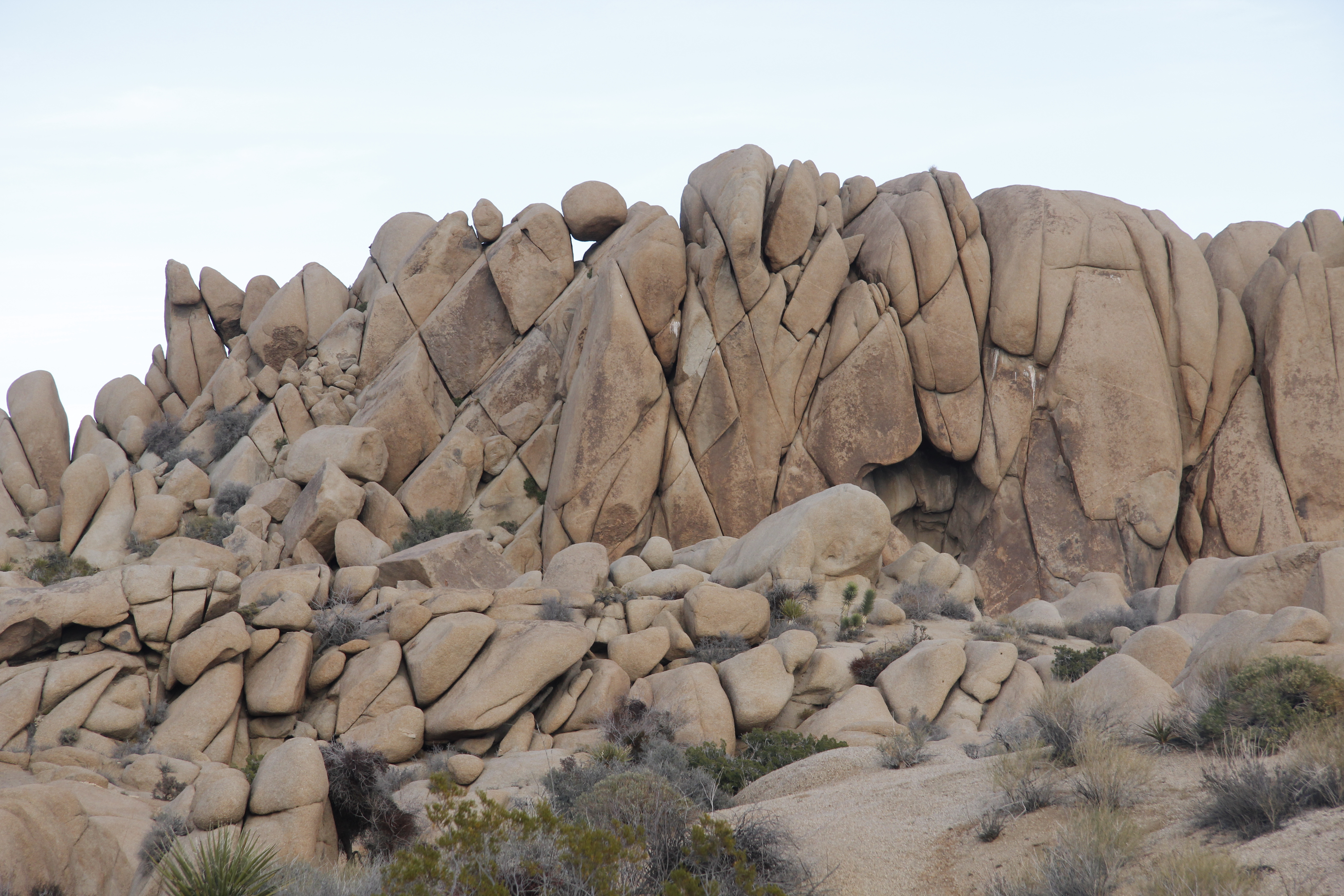
The rocks that define Joshua Tree's skyline — the great gray rounded boulders of the Wonderland of Rocks, Jumbo Rocks, and Hidden Valley — are monzogranite, a type of granite that formed from 250 to 75 million years ago as tectonic plate movements drove the Pacific Plate beneath the North American Plate in a slow collision that sent volcanic material forcing its way upward through the crust.
This molten material — called magma — never reached the surface. Instead, it oozed upward and then cooled slowly, miles underground, surrounded by the pressure and insulation of the overlying rock. Magma that cools this way, underground and slowly, is called plutonic rock. The slowness of cooling is crucial: it gives mineral crystals time to grow large, which is why granite feels rough and grainy rather than smooth. The large crystal size is also responsible for that distinctive sparkle — the light catching feldspar, quartz, and dark biotite mica crystals of different sizes.
The specific rock type that formed here — monzogranite — gets its name from its mineral composition: intermediate between granodiorite and granite, with roughly equal proportions of potassium feldspar and plagioclase feldspar, along with quartz and dark ferromagnesian minerals. Climbers often call it "quartz monzonite," and its coarse, crystalline texture is precisely what makes it such an exceptional climbing surface — but we'll come to that.
The Fracture System
How the Monzogranite Cracked: Three Joint Sets
The monzogranite didn't just cool and sit there. As millions of years of erosion removed the miles of overlying rock — slowly reducing the enormous weight pressing down from above — the monzogranite experienced what geologists call "pressure release." With the overburden removed, the rock expanded and cracked in a very predictable, geometric pattern.
Three distinct joint sets developed in Joshua Tree's monzogranite, and understanding them explains almost everything about the park's visual character:
You can see the joint system in action at Jumbo Rocks Campground, Split Rock, and throughout the Wonderland of Rocks. The regularly spaced parallel fractures creating clean, rectangular blocks are unmistakable once you know what you're looking at.

The Rounding Process
Spheroidal Weathering: From Cubes to Boulders
With the joint system in place, the next chapter of Joshua Tree's geology begins — and it happens underground, invisibly, over millions of years, during a time when this desert was much wetter than it is today.
Groundwater percolated down through the rectangular joint fractures of the buried monzogranite, and as it did, it began chemically altering the rock along the water's path. The feldspar minerals in the granite are particularly susceptible to chemical weathering — water and dissolved acids react with them, converting hard feldspar crystals into soft clay minerals. Meanwhile, quartz grains — more resistant to chemical alteration — were loosened and freed from the surrounding matrix.
The key insight of spheroidal weathering is this: the corners and edges of each rectangular block are attacked by groundwater on multiple sides simultaneously, while the interior of each block is reached by water from only one direction. The corners weather fastest. The edges weather second. The flat faces weather most slowly. The result is precisely what you'd expect: rectangular blocks are progressively rounded off at the corners, then at the edges, and eventually become roughly spherical — hard kernels of unweathered rock surrounded by a soft matrix of clay and loose mineral grains, all while still buried underground.
Think of holding an ice cube under a running faucet — the cube rounds away at the corners first, because that's where the water has the most contact. The same geometry operates here, just over millions of years, on a grand scale, during a much wetter climate than the park experiences today.


The Finishing Touch
Flash Floods and the Desert's Reveal
The pre-rounded corestones sat buried in their soft matrix of clay and loose minerals for millions of years. Then the climate changed. The wet, relatively temperate conditions that enabled deep groundwater percolation gave way to the arid desert conditions of the present. With less infiltrating groundwater to sustain the weathering process, chemical alteration slowed dramatically.
But what the desert took away in groundwater it replaced with flash floods — sudden, violent, intermittent surges of water that scour the desert floor with tremendous force. Flash floods carry enormous quantities of sediment and are extraordinarily effective at stripping the soft clay-and-grain matrix that surrounds the hard corestones underground. As the protective surface layer was eroded away, the pre-rounded boulders were exposed for the first time — and then they settled, under their own enormous weight, into the stacked configurations we see today.
This is why Joshua Tree's boulder piles look the way they do: they are essentially landslide deposits, with boulders that were pre-shaped underground settling gravitationally onto one another as the soft matrix between them was carried away. The dramatic stacking — enormous rounded rocks perched apparently precariously on one another — reflects the geometry of how spherical objects settle when the material around them is removed.
Jumbo Rocks: The Clearest Example
Jumbo Rocks Campground offers perhaps the clearest view of this process in action. The huge rounded boulders there — many six or eight feet across, stacked three and four high — are clustered in exactly the pattern you'd expect from ancient corestones settling after their matrix was scoured away. The campground sits among geologic evidence that took 100 million years to accumulate.
Dark Lines in Light Rock
Dikes: The Desert's Stonework
Look closely at any Joshua Tree boulder and you're likely to see dark, linear intrusions running through the gray monzogranite — sometimes thin as a pencil, sometimes broad as a hand, often cutting across the boulder in ruler-straight lines. These are dikes.
Dikes are veins of younger igneous rock that formed when molten material was pushed into existing joint fractures in the already-cooled monzogranite. Because the surrounding monzogranite had already solidified and its joint system was already in place, the magma found the path of least resistance — the existing fractures — and flowed into them. As it cooled, it solidified in the shape of those fractures: thin, flat, geometrically regular sheets running through the host rock.
The most common dike types in Joshua Tree are aplite (a fine-grained, light-colored granite), pegmatite (extremely coarse-grained, often with large crystals of quartz, feldspar, and occasionally tourmaline or garnet), and andesite (a darker, finer-grained volcanic rock). When exposed at the surface, dikes often break into uniform rectangular blocks — the NPS describes their appearance as suggesting "the work of a stonemason," and the description is apt. You'll see them everywhere once you know what to look for.
Elevation as Destiny
Two Deserts, One Park
Joshua Tree National Park occupies a geologically significant transition zone: the boundary between two desert ecosystems determined primarily by elevation. The park straddles both, with dramatically different landscapes on either side of the roughly 3,000-foot contour line.
The higher, cooler Mojave Desert occupies the western and northern sections of the park, including the Wonderland of Rocks, Hidden Valley, Jumbo Rocks, and the park's most dramatic boulder formations. Cooler temperatures and slightly higher precipitation allow more plant diversity.
This is where the park's namesake trees — Joshua trees (Yucca brevifolia) — grow in their characteristic forest patterns, from dense groves to distantly spaced specimens. Piñon pine, California juniper, and desert scrub oak also occur here.
Key plants: Joshua tree · piñon pine · California juniper · desert scrub oak · cholla · prickly pear
The lower, hotter Colorado Desert — a subdivision of the Sonoran Desert — occupies the eastern half of the park, including the flat expanse of the Pinto Basin. With lower elevation and higher temperatures, it supports a distinct plant community dominated by lower-profile, drought-adapted species.
The Cholla Cactus Garden, located in the Colorado Desert section, is one of the park's most visited natural attractions. Five native oases of California fan palm (Washingtonia filifera) occur in this zone, wherever water emerges naturally year-round.
Key plants: creosote bush · ocotillo · teddy bear cholla · ocotillo · desert saltbush · California fan palm (oases)
The transition between the two desert zones is not a sharp line — it's a gradient, blurring across several hundred feet of elevation. But the contrast between the boulder-studded Joshua tree forest of the park's western reaches and the flat, creosote-dotted expanse of the Pinto Basin is one of the most striking ecological contrasts in any national park in the American West.

Tectonic Forces
Fault Lines: How the Mountains Were Made
Joshua Tree National Park sits within one of the most tectonically active regions in North America — the broad zone of deformation associated with the boundary between the Pacific and North American plates. The San Andreas Fault is the most famous expression of this plate boundary, and while the fault itself passes southwest of the park, its influence on the landscape is everywhere.
The Transverse Ranges
Five of Joshua Tree's six mountain ranges — the Little San Bernardino, Hexie, Pinto, Cottonwood, and Eagle Mountains — are part of the Transverse Ranges, an east-west trending chain of mountains unique in California. Most California mountain ranges trend northwest-southeast, parallel to the coast and to plate motion. The Transverse Ranges buck this pattern, running east-west instead — a consequence of compressional forces along the San Andreas Fault system that twisted and compressed the crust perpendicular to the direction of plate motion.
The sixth range, the Coxcomb Mountains in the park's eastern section, runs north-south and is part of the Basin and Range Province — a geologically distinct zone of extended, stretched crust that dominates the desert Southwest.
Faults Within the Park
Several fault lines run directly through the park, including the Dillon, Blue Cut, and Pinto faults — all related to the broader San Andreas system. These faults have caused earthquakes historically, and their presence has influenced the park's landscape in subtler ways: controlling where water emerges at the surface (some of the park's oases and seeps occur along fault zones where impermeable fault material forces groundwater upward), and creating the valley floors and basin shapes between the mountain ranges.
Keys View: The San Andreas From Above
The most dramatic geological viewpoint in the park is Keys View, at 5,185 feet in the Little San Bernardino Mountains. On a clear day, the view takes in the entire Coachella Valley below, the distinctive linear trace of the San Andreas Fault running through the valley floor, the Salton Sea glittering in the southeast, and the Santa Rosa Mountains beyond. The fault is visible as a long, straight valley — a topographic signature of the grinding, locked plates on either side, building stress that will eventually release in another major earthquake.

Surface Textures
Tafoni, Potholes, and the Desert's Detail Work
The geology of Joshua Tree doesn't end with the major boulder formations. Look closely at the rock surfaces and you'll find a world of smaller-scale geological features, each produced by distinct processes operating at the boulder's skin.
Tafoni
The honeycomb-patterned cavities visible on many boulder surfaces are called tafoni (singular: tafone). They form through a combination of salt weathering and differential erosion. Water carrying dissolved salts infiltrates tiny pores in the rock surface; as the water evaporates, the salt crystals expand and mechanically pop off tiny flakes of rock. Over time, the pits deepen and widen, merge with adjacent pits, and develop into the cavernous, sponge-like cavities that characterize many Joshua Tree boulders. The pattern is particularly pronounced on surfaces that receive intermittent moisture — east- and north-facing sides of boulders, areas near desert varnish, and wherever biological soil crusts have been disturbed.
Potholes and Tanks
Many granite boulders in Joshua Tree contain weathering pits or potholes — rounded, bowl-shaped depressions in the rock surface that collect rainwater and support small desert ecosystems. Called "tinajas" in the Southwest, these features were critical water sources for the Native peoples who lived in and moved through the park's landscape for thousands of years. The famous Barker Dam, built by ranchers in the early 1900s and expanded by Bill Keys, is essentially a concrete wall built across a natural rock basin to enlarge an existing water-capture feature.
Desert Varnish
The dark brown or black coating you'll see on many rock surfaces — particularly on cliff faces and large boulders — is desert varnish, a manganese- and iron-oxide-rich layer deposited by microorganisms and wind-blown dust over hundreds to thousands of years. Desert varnish accumulates at a rate of roughly one micron per century and can be used by geologists to estimate minimum surface exposure ages. It is also the surface that Native peoples selected for petroglyphs — pecking through the varnish to expose the lighter rock beneath, creating images that have endured for thousands of years.

Why Climbers Love It
The Best Rock in America: A Climber's Geology
Joshua Tree has been a premier rock climbing destination since the 1950s, when members of the Yosemite climbing community discovered that the desert monzogranite offered something qualitatively different from any other rock they'd climbed. Sixty years later, the park has over 8,000 documented climbing routes, more than any other desert destination in the American West. The geology explains why.
Why Monzogranite Climbs the Way It Does
Monzogranite is a coarse-grained rock — its crystals are large, interlocking, and protrude slightly from the surface. Unlike polished granite (which feels glassy and slick) or smooth limestone (which can feel featureless), Joshua Tree monzogranite feels almost like sandpaper under your palms. The friction is extraordinary. Climbers can smear their feet on seemingly blank faces and trust that the rubber will hold. This quality — called "friction climbing" — is particularly well-developed at Joshua Tree precisely because the rock is never polished by ice or glacial action, as it would be in Yosemite or the Sierra Nevada.
Crack Systems
The three-joint system that cracked Joshua Tree's monzogranite into rectangular blocks also produced the clean, parallel crack systems the park is legendary for. Where two joint surfaces meet, the resulting crack is often perfectly continuous, smooth-edged, and consistent in width for dozens of feet — ideal for crack climbing, where hands and feet are jammed into the crack at different widths to create upward progress. The famous "hand crack" and "fist crack" sizes at Joshua Tree are direct products of the spacing of the joint system, which creates gaps consistently in the range climbers find most useful.
The Scale
Joshua Tree routes are almost never very tall — the boulders and outcrops rarely exceed 200 feet, and most climbing is single-pitch (completed with one rope length). But this works entirely in the park's favor. A single day in Joshua Tree can cover six or eight different climbs across three or four different formations — a variety of rock experiences that would take days at a taller cliff. And the short approaches — often just a short walk from a parking area — mean more time on rock and less time hauling through wilderness.
The Future
Geology Endures; Climate Changes
The boulders of Joshua Tree will outlast almost anything. The monzogranite has been here for 100 million years and will be here for many millions more. But the biological communities that depend on this landscape — the Joshua trees themselves, the desert tortoise, the desert bighorn sheep — are acutely sensitive to climate change, and the data from Joshua Tree is stark.
From 1895 to 2016, annual precipitation in the park dropped by 39% and average annual temperature increased by 3°F. Climate models project an additional 8°F increase in average temperature by 2099 under high-emission scenarios — a change that would render most of the park's current area unsuitable for Joshua tree growth. The 2020 Dome Fire burned more than 43,000 acres in the park's western section, killing tens of thousands of Joshua trees in a fire event historically unprecedented in this landscape.
The geology is the constant. The desert communities that evolved to live within it are what's at risk — and what conservation in the 21st century is charged with protecting, in a landscape that Minerva Hoyt first argued was worth saving nearly a century ago.
Go Deeper
More Joshua Tree Guides
Frequently Asked Questions
Joshua Tree Geology: Common Questions
Touch 100-Million-Year-Old Rock with a Local Expert
Summit Climbing Guides leads rock climbing, boulder scrambling, and cave adventures across Joshua Tree's ancient monzogranite — for every ability level, all year round.
Book Your Adventure